The North Fork and Smith Fork of the Gunnison River watersheds are home to unique ecosystems and key rural communities on the western slope of Colorado. The watersheds are locally referred to as the North Fork Valley. The North Fork Valley has been playing an increasingly important role in Colorado’s agricultural and recreation economy over the last 20 years. Changes in local economy and demographics have resulted in increased human population and overall community growth. As the communities of North Fork Valley have expanded, contact between the Wildland Urban Interface (WUI) has proportionally increased. The three communities of these watersheds (Hotchkiss, Paonia, Crawford, and Somerset) exist within topographical and climatic conditions that support fuel loads that are highly conducive to the risks of rapid and intense wildfires.
These primarily agricultural communities are supported by expansive water delivery systems that provide domestic and agricultural water resources from the surrounding mountains and rivers to the North Fork Valley. Many will remember when, on July 4th, 1993, a devastating wildfire located on Wake Mesa, north of Paonia, showcased the level of wildfire intensity that is possible with local fuel loads. Several homes were destroyed and the community left in shock at the wildfire’s speed and intensity. A burn scar still stands to this day where high intensity heat sterilized the soil and seed bank of the Mesa’s slope, preventing regrowth. Multiple wildfires have ignited within the North Fork Valley since that time, but all have been reasonably contained by the quick thinking work of the Valley’s all-volunteer fire departments.
Recently, the Western Slope Conservation Center (WSCC) received funding through the Colorado Water Conservation Board (CWCB) to undertake a Wildfire Ready Watershed, Wildfire Ready Action Plan (WRAP) with support from many local stakeholders. WRAPs are aimed at looking at post-fire susceptibility across the watershed. After a wildfire comes through a landscape, the impacted area can be faced with floods, mud flows, debris flows, landslides, hillslope erosion, etc. These hazards are often not identified or analyzed by other Community Wildfire Protection Plans. These hazards provide a whole host of potential susceptibility to life, property and any downstream assets, such as municipal water supply, irrigation diversions and infrastructure, reservoirs, etc. A WRAP serves to mitigate these risks by providing important pre-fire data collection, data gap analysis, identification of community values at risk, post-wildfire hazard analysis, and susceptibility analysis of values at risk. This robust data and analysis can help current and future wildfire planning within a community. For instance, this project will complement Delta County’s work to update their Community Wildfire Protection Plan. Most importantly, a WRAP provides a funding framework, called an Action Plan, for implementing pre-fire and post-fire mitigation activities.
The North Fork and Smith Fork WRAP stakeholder group is composed of local, state, county, and federal government entities as well as private landowners, nonprofit organizations, municipalities, fire districts, agricultural water districts, and domestic water companies. The goals for the North Fork and Smith Fork, WRAP are to:
-
- Identify values at risk to post-fire conditions
- Gather and identify relevant data, determine gaps in the data
- Identify and analyze hazards from post-fire conditions
- Analyze susceptibility of values at risk
- Create a pre-fire and post-fire action plan to mitigate hazards and reduce susceptibility to values at risk
- Create a shared understanding via stakeholder collaboration.
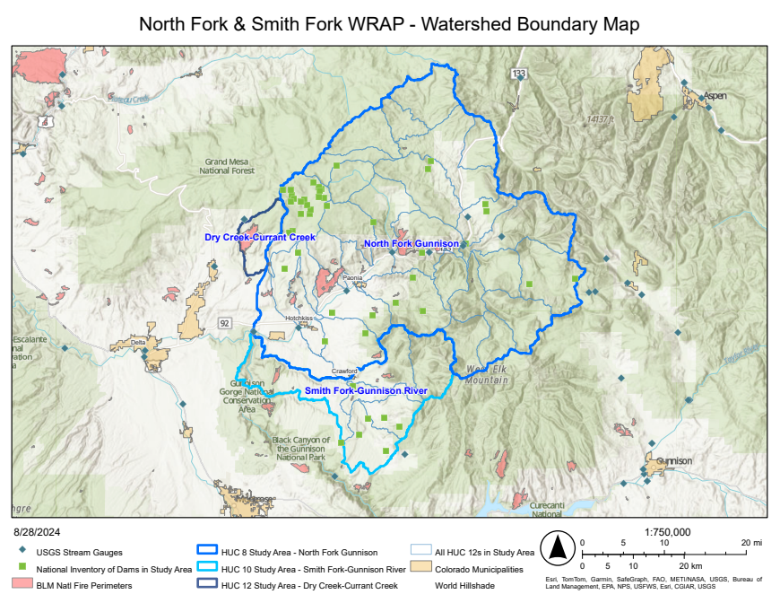
The North Fork and Smith Fork WRAP will focus on the North Fork of the Gunnison Watershed HUC 14020004 and Smith Fork of the Gunnison HUC 140200212, as well as the upper Currant Creek watershed HUC 140200050101. The watershed’s boundaries as defined encompass over 1,200 sq miles, and includes 34 smaller HUC 12 watersheds. While Upper Currant Creek’s boundary exists outside of the North Fork HUC, it has been included because it bridges an important gap between the North Fork and a neighboring WRAP being undertaken by the Grand Mesa Resiliency Partnership west of the study area.
The final goal is to use the WRAP to prioritize funding needs and future project implementation for effective and lasting protection of at-risk assets from future wildfires and enhancement of watershed health as a whole. To learn more about WSCC’s Wildfire Ready Watersheds program, contact [email protected]

