

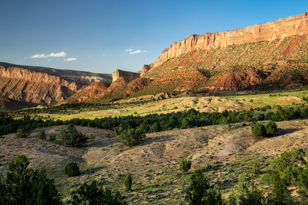
Sewemup Mesa Wilderness Study Area (pictured) would not be fully protected by the NCA proposal. Photo Credit: Bob Wick, BLM.
The Western Slope Conservation Center (WSCC) has worked for nearly 50 years to promote locally-led conservation solutions on public and private lands in the North Fork Valley and surrounding areas. Countless travelers from across the western slope, Colorado and the United States have long sought out the Unaweep Tabeguache Scenic Byway for the chance to marvel at the red rock walls along the Dolores River. Those of us lucky enough to have spent more time in this area quickly recognize that the opportunities to explore, fish, hunt, and raft should be protected for the benefit of future generations. The growing momentum surrounding efforts to protect the Dolores Canyons National Monument provides a unique opportunity for all stakeholders to conserve the existing values of this area.
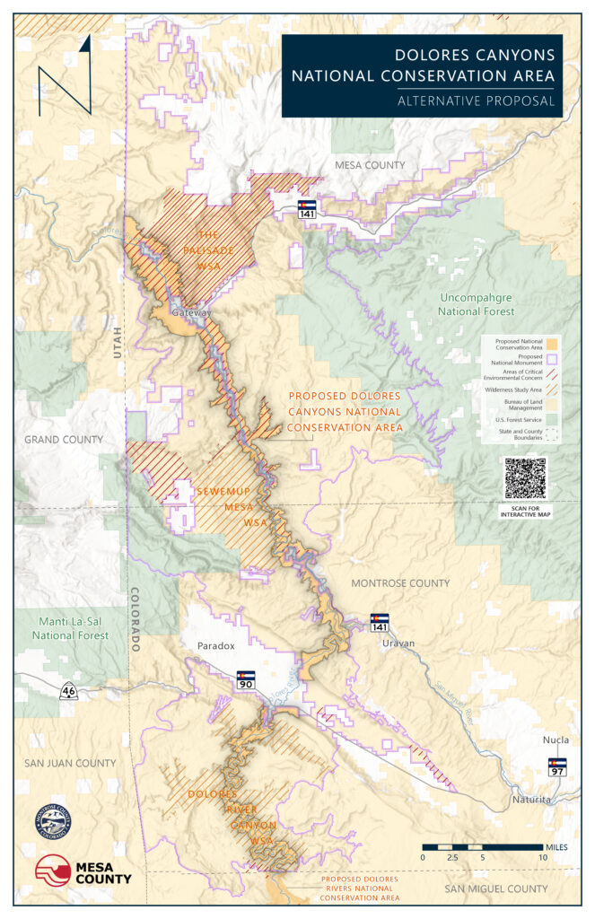
Any conservation protections for the Dolores Canyons should recognize the historical uses of these canyons and mesas, but Mesa and Montrose Counties’ National Conservation Area (NCA) proposal attempts to achieve this by excluding many of the most important conservation and wildlife areas on the landscape. By focusing only on the river corridor, this proposal fails to see the Dolores Canyons as an interconnected landscape critical for wildlife conservation and climate adaptation. Additionally, the NCA proposal refuses to recognize the majority of existing Wilderness Study Areas adjacent to the river corridor, and does little to acknowledge Indigenous cultural sites or tell the history of settlement, mining, and ranching in this area.
WSCC is encouraged by the recognition that a protective designation may be the best way to balance conservation goals with other multiple-uses and economic opportunities, but we are disappointed by the extremely limited conservation vision presented by the Counties’ NCA proposal. We believe that landscape-scale protections for the Dolores Canyons would be the best way to achieve balance and maintain resilient ecological systems, where water management, agricultural practices, and recreation opportunities allow people and local economies to flourish.
From our years of work we know that locally-led conservation solutions are more likely to earn consensus and achieve durable solutions. We also know that a single public poll or conservation proposal is unlikely to reflect the full range of attitudes regarding public lands conservation in our communities. However, in our analysis of the current NCA proposal, it does not sufficiently represent the robust public support for public lands protections in Colorado nor does it address many of the conservation needs throughout the Dolores Canyons.
At WSCC, we pride ourselves on an informed and engaged community of members committed to protecting and enhancing the lands, air, water and wildlife of the Western Slope. We appreciate Mesa and Montrose Counties coming to the table regarding the future of the Dolores Canyons and look forward to submitting comments on the NCA proposal.
WSCC encourages members of our community, especially individuals living in Mesa or Montrose Counties, as well as those familiar with the Dolores Canyons area, to weigh in with written comments at the link below the proposed Dolores Canyons NCA Map. The Counties’ proposed NCA is approximately 92.5% smaller than the proposed Dolores Canyons National Monument. You may also choose to contact your local County Commissioners, State Representatives, and/or Federal Elected Officials in support of landscape-scale protections for the Dolores Canyons National Monument.
Mesa & Montrose Comment Form: https://form.jotform.com/242036273331043
Personalized, substantive comments naming specific values and areas will be the most impactful. Please feel free to add your own thoughts to any comments which may be copied in part or full from the below resources.
Values to Highlight:
National Monuments are an effective conservation tool and help protect “historic landmarks, historic and prehistoric structures, and other objects of historic or scientific interest”. The proposed Dolores Canyons National Monument better represents these values, while the NCA proposal is far too limited in its approach.
Documented and undocumented Indigenous Cultural Sites can be found within the landscape. A National Monument would allow for further documentation, protection, and interpretation of these sites. Other nearby Colorado areas like Canyons of the Ancients National Monument contain high concentrations of Indigenous sites and artifacts.
The history of this area includes ranching, globally significant uranium mining, and accompanying historic sites. There is also a rich geological and Indigenous history that would be better represented by the National Monument proposal.
The iconic Palisade Buttress, sheer canyon walls, and a range of habitats across expansive plateaus and high-altitude, forested mesas are a few of the spectacular geological stories spanning the 160+ million years of geological time across the Dolores Canyons National Monument area.
Highlighted Below is the Significance of Specific Areas within the proposed Dolores Canyons National Monument. All of these areas are mostly absent or underrepresented by the NCA proposal. Landscape-scale protections for the Dolores Canyons should include:
Conservation, Historical Significance: Tenderfoot, Flat Top, Calamity, Outlaw and Blue Mesas host historical sites such as uranium mining camps and old mining structures that help tell the story of people on this landscape and preserve the globally-significant history of mining in the Dolores region. Calamity Mesa is home to Calamity Camp, a series of still-standing stone houses built by miners and their families in the 1920s. The Camp was added to the National Register of Historical Places in 2011. See page 10 here for additional details.
Conservation, Wildlife, Watershed, Wilderness: Roc Creek and Sinbad Ridge: Higher elevation woodlands anchored around one of the few perennial streams flowing into Colorado from Utah’s La Sal Mountains. These areas provide cold-water habitat for Colorado River cutthroat trout and maintain an important migration corridor between Colorado and Utah. Diverse riparian ecosystems support native reptiles, amphibians, and high-quality winter range for elk. Recommended for wilderness designation by the Forest Service. See here for additional details.
Conservation, Watershed, Wildlife: Slopes of the Uncompahgre Plateau: Mid-elevation uplands around the headwaters of cold water streams like Blue, Mesa, and Ute Creeks which are important to big game, turkey, and bald eagles. The range of habitats on the Uncompahgre Plateau shift from piñon-juniper woodlands to higher-elevation ponderosa and aspen providing important migratory habitat.
Conservation, Roadless Values, Wildlife, Geology: USFS Colorado Roadless areas, including Unaweep (Upper tier roadless area), Calamity Basin, Long Canyon. Unaweep Canyon is geologically unique with two streams—East Creek and West Creek—flowing in opposite directions out of either end of the canyon. The cliff walls are formed from Precambrian rocks from the earliest period in Earth’s history. See here for additional details and here for an online map.
Conservation, Wildlife, Watershed, Wilderness, Geology: The entirety of the Sewemup Mesa, The Palisade and Dolores River Canyon Wilderness Study Areas, which for over 40 years have been administratively managed by BLM to preserve their wilderness characteristics. Because of its sheer cliffs, Sewemup Mesa WSA is one of the most ecologically intact ecosystems in Colorado that supports rare plant species and habitat for big game like elk, mule deer, and desert bighorn sheep. The iconic buttress of The Palisade WSA rises 1,700 feet above the Dolores River with hoodoos, cliffs, waterfalls, and habitat for the threatened silverspot butterfly. The network of canyons in the Dolores River Canyon WSA contain clear exposures of 160-million-year-old rocks; and opportunities for backpacking, hiking, rock climbing, and whitewater rafting.