
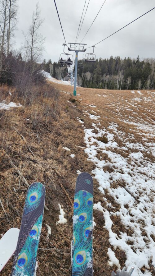
Ah, spring is in the air and with the warm temperatures comes the rush of melting snow to our rivers and streams. Ditches have turned on, and it’s time to hang up those skis and start dusting off those boats. We thought it was a good time to recap the winter and discuss the current water outlook. If you will recall our earlier Snowpack Report from January 20th, you’ll remember that we were waiting for the big snow to show up so that we could put away our “rock skis” and get on with our quest for Colorado champagne pow. But what happened next was crazier than anyone expected.
All winter long we were dancing with a record setting low snowpack. Despite all of our efforts: snow dances, New Year’s resolutions, and sacrificing of old skis to the fires of Ullr, there seemed to be nothing that could break us above the lowest snowpack on record in the last 30 years. The only solace we had was that all of Colorado seemed to be in the same dismal boat. Much has already been written on the state of the snowpack for Colorado, so let’s take a dive into the local level. The North Fork of the Gunnison – the Winter that Wasn’t.
The winter of 2025/26 included 5 major snowstorms that shaped the curve of our Snow Water Equivalent (SWE) graph:
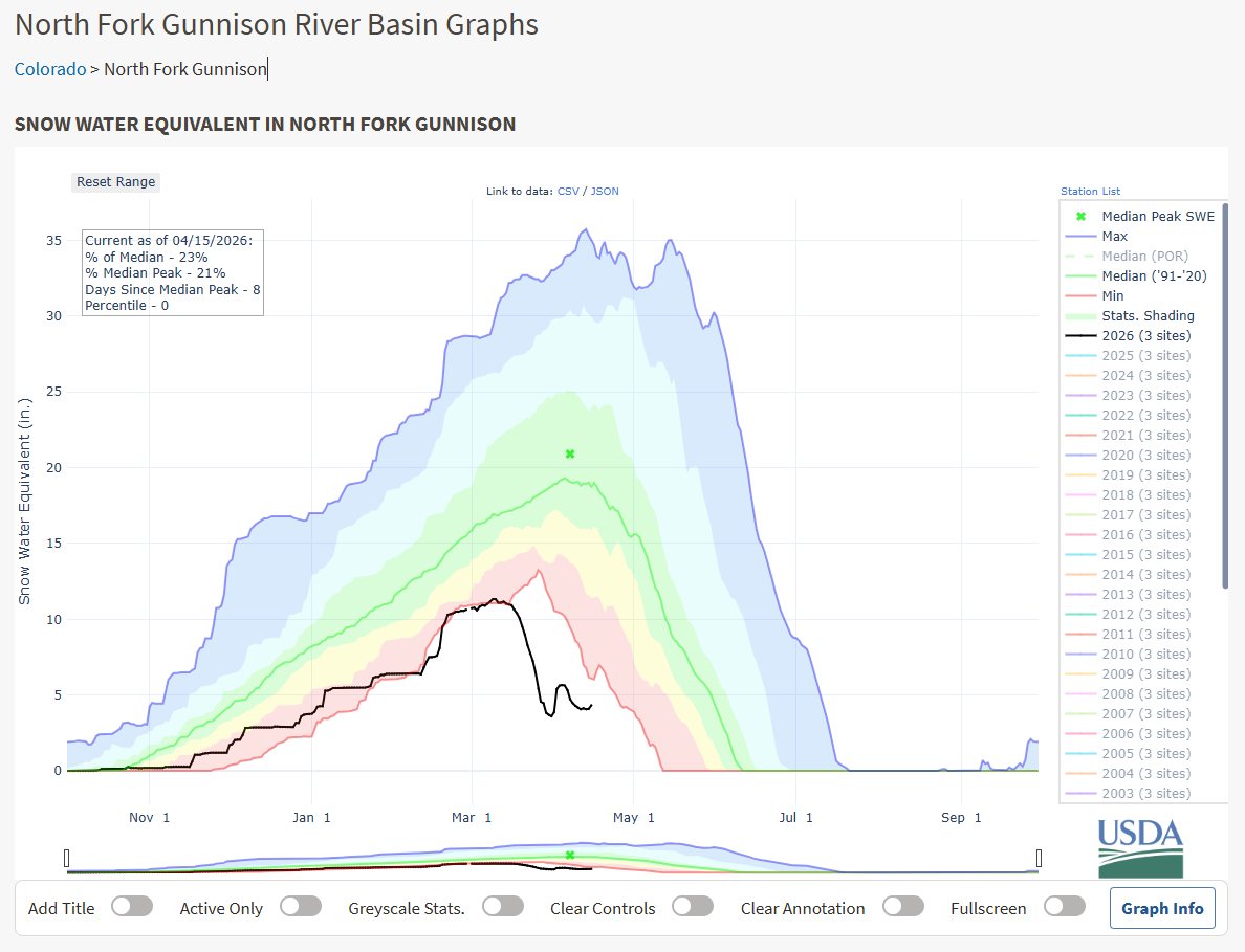
November 17 – 21: The first storm of the season brought almost a full inch of rain to the North Fork Valley and the first sign of snow on the mountains. The storm was pretty late to the party already, but we were glad to see it.
December 1 – 4: This colder storm finally brought about 6 inches of snow accumulating on the valley floors and began to develop the mountain base. SNOTEL SWE jumped to 2.8 inches and it looked like we might be coming out of the red zone.
December 25 – Jan 9: Nearly a whole month had gone by since this storm showed up, and this was the holiday event that we were all waiting for. Unfortunately, this storm was warm and snow was confined to elevations above 8,000 ft. However, the week of January 1-9 delivered a full inch of rain to the North Fork Valley. Despite the warm temps, this storm stretched out for almost 2 weeks and did bring our SWE back up to the top of the red zone.
January 24: This was a quick cold storm. The kind that we like to see in Colorado. It did contain some moisture with 5 inches of snow accumulating on the valley floor and bumped the mountain SWE up slightly. We were hopeful for a lot more of these to come.
February 11 – 21: Finally a storm that delivered. This long running storm system began with drizzle and rain at elevations below 8,000 ft. However, between Feb. 20-21, a cold front brought 7 inches of fluffy snow to the valley floors. The high country received 2-3 feet of snow throughout this storm cycle, again bringing us out of a record low snow year, but not out of the red.
All in all, the North Fork Valley floor received approximately 4.0 inches of water in either rain or melted snow throughout the 2025/26 winter. Snowfall accumulation in the valley was about 23 inches according to the Community Collaborative Rain, Hail, and Snow network (CoCoRaHS). However, what isn’t evident from this review of last winter’s storm cycles is what transpired between the storms. According to the Colorado Climate Center, this past winter was the warmest on record, exceeding the average temperature in over 150 years by almost 3.5 degrees. Coloradans are used to warm sunny days between snowstorms. We tend to look at these “blue bird” days with mixed emotion when the sun is warm on our skin, but also creating a melting layer that turns to crust as overnight temperatures dip.
What made this winter different from others was the warm temperatures between storms. This reduced the snowpack in such a way that the mountains were never able to develop a deep firm base. You will likely remember how common it was this winter to find bare ground at ski resorts while the valley temperatures ran close to 60 degrees even in February. Without a firm base, the 5 storm systems produced snow that easily melted between events due to Colorado’s intense sunshine and unseasonably warm temps.
Then came March madness. No, not the college basketball tournament, but the kind of madness that sent our snowpack bouncing down the mountains into a court of oblivion. That last week of March set record breaking digits with high temperatures in the North Fork Valley exceeded 85 degrees for the entire week. The weak winter snowpack in the mountains didn’t stand a chance. Runoff began to ramp up on March 16th and by April 1st the snowpack was reduced from 64% to only 20% of average for the season, plummeting well below the lowest levels in recorded history. It wasn’t until April 1st that we came out of the March madness dive bomb, when a spring storm brought nearly 2.0 inches of rain to the North Fork Valley. Even so, the record setting meltdown had done its damage to the basin snowpack.
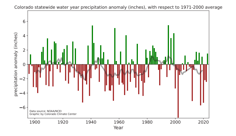
Looking back at the winter, it’s clear that temperature was in the driver’s seat the whole time. This lines up with an even longer trend for Colorado and the western United States. The trend is that over the last 150 years, precipitation has stayed largely stable throughout the state (Colorado Climate Report):
However, a different story is told when looking at average temperatures over the last 150 years (Colorado Climate Report):
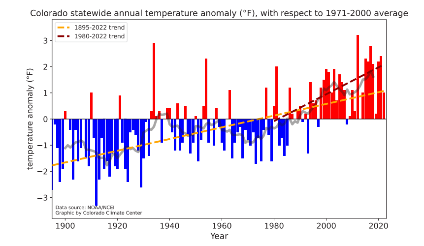
This proved to be the case for the winter of 2025/26. Precipitation levels were slightly below average for the western slope of Colorado. However, the exceedingly warm temperatures melted away any gains in our snowpack throughout the season. It’s clear that climate change is playing a significant role in the future of water availability in our state.
The warm temperatures this winter also had an impact on soils and vegetation in the North Fork Valley. When March madness hit, most of the vegetation, including fruit trees and pastures, began to come back to life. This had producers calling for irrigation ditches be turned on to support growing crops. The North Fork of the Gunnison river was showing signs of early season runoff as well, and water managers responded by sending water to farms nearly an entire month earlier than average turn out date.
Speaking of North Fork river flows, it’s always anyone’s guess as to when the peak runoff will occur. But this year may prove to be the first time that the North Fork has reached peak runoff BEFORE the median snowpack peak. North Fork peak runoff typically occurs in mid May. However, this year with most everything running about one month ahead of schedule, it is likely that we will see diminishing flows from here on out. Below is a graph of the North Fork USGS gauge at Somerset as, displayed by the Colorado Basin River Forecast Center (CBRFC), showing historical average peaks over the last 100 years:
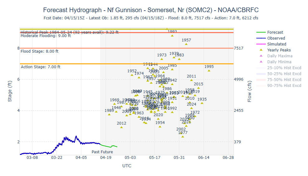
The blue line is our current observed hydrograph. The green line is a projection for the coming week. If the downward trend continues, March 2026 will have its own yellow triangle standing alone in the far lower left of this graph next year. This would represent the lowest and earliest peak runoff has occured on the North Fork. However it plays out, it’s clear that this winter will prove to have huge impacts on water availability for this summer. While this sounds like a lot of doom and gloom, there are some signs of hope.
Before we close out this post, allow us to take you back in time to another year when all hope was lost and the atmosphere made an amazing recovery. Many of you will remember 2015 as a year that was in a somewhat similar dire situation to this year. March of 2015 saw a dismal snowpack, an early peak SWE, followed by a warming trend that was melting the snowpack and breaking records. The North Fork Valley was bracing for a record low water year. However, a strong El Nino pattern set up and rain began to fall through the months of April and May, bringing snow to the mountains and stretching the SWE graph out through early June. Locals refer to this as the “Miracle May”, and it exhibits a similar pattern to our current situation:
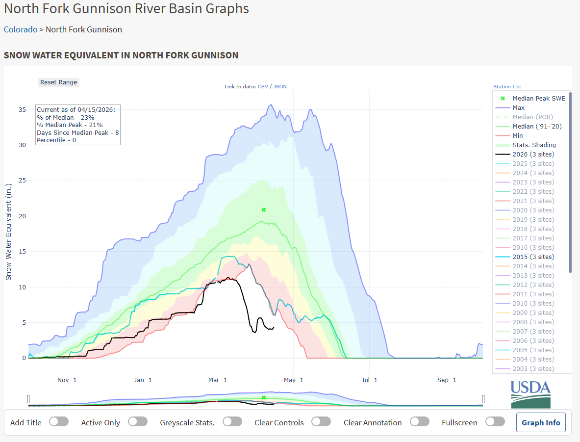
The teal line is the water year 2015 and the black line is our current water year 2026. While our SWE is sitting significantly lower, the two years do show similar trends. Recently, NOAA again released its projection for a Super El Nino in the process of development for the summer of 2026. The coming weeks are indeed forecast to be stormy and this could result in a strong monsoon season for southwest Colorado. Whether this shift in atmosphere continues to hold with results in a similar miracle for 2026, is still “up in the air” (pun intended!) but let’s hope that some sort of moisture continues to come our way.
Photo credit: Ashley Garrison
Leave a Reply